گروه کوهنوردی شیراز
گروه کوهنوردی شیراز در زمینه های کوهپیمایی / غارنوردی / صعود قله / و... فعالیت می نماید و از علاقمندان به طبیعت و کوهنوردی نام نویسی می نمایدگروه کوهنوردی شیراز
گروه کوهنوردی شیراز در زمینه های کوهپیمایی / غارنوردی / صعود قله / و... فعالیت می نماید و از علاقمندان به طبیعت و کوهنوردی نام نویسی می نمایدdena mountin
Overview
Plateau of Iran resembles a triangle
between two recesses. Western and northern parts of this triangle are
limited to Zagros and Alborz mountain ranges respectively. Zagros
Mountain Range extends from NW to SE of Iran. At its far southern end,
after passing along the eastern coasts of Persian Gulf, Baluchestan an
Afghanistan and the sparsely populated coastal areas of Indian Ocean, it
turns to join Hendukosh Mountains separating from Pamir.
Like other highlands of Iran, Zagros is the result of orogenetic movements during Pliocene era. During this period, sea water retreated from Iran’s mainland for the last time, leaving behind thick layers of sedimentary conglomerates.
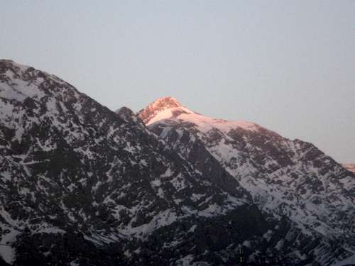
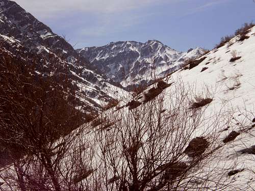
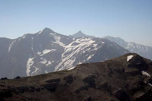
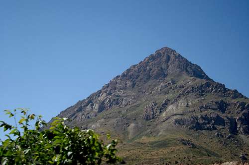
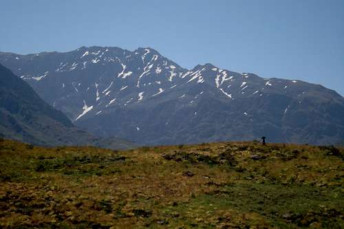
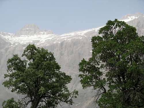
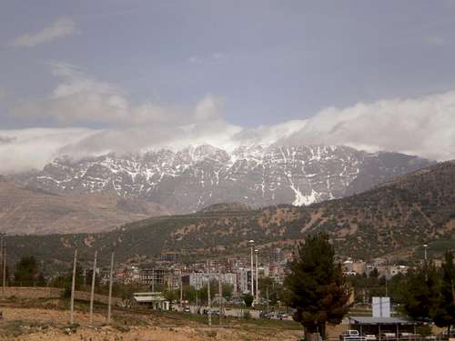
Zagros is 1250 km long (from Marivan Valley to Hormoz) and 160-360 km wide. Relatively wet, warm and cold climates can be found in Zagros. The vegetation is rich and diverse including 10 million ha of oak forest and also wild pistachio forests at its south-eastern end. Hillocks are up to 1000 m high while mountain peaks elevation varies from 2000m to 4000m. The highest peaks of Zagros, of which the highest one is Ghashmastan (4435m), are located in the high mountains of Dena.
Zagros region includes provinces of Kordestan, Kermanshahan, Hamedan, Lorestan, Ilam, Isfahan, Chahar-Mahal-Bakhtiari, Kohkiluyeh & Boyer-Ahmad, Fars, Bushehr, and parts of Markazi, Khuzestan, and Hormozgan Provinces.
Kurd, Lor and Lak nomadic people live in Zagros. Kurds live in Kurdestan, Ilam, and west of Urmieh Lake, Lak nomads live in the north and northwest of Lorestan, while Lors reside in other parts of Lorestan as well as parts of Ilam, Chahar-Mahal-Bakhtiari, Kohkiluyeh & Boyer-Ahmad, Fars, and Busher provinces. Lors who live in Lorestan are called Junior Lors while others who reside in other regions are called Senior Lors. Members of Bakhtiari Tribe, the largest migratory tribe in the country, live in Chahar-Mahal-Bakhtiari, while members of other reside in Kohkiluyeh & Boyer-Ahmad, Bahmani and Mamasani.
The southern end of Zagros down to Larestan has a warm climate (250 mm annual precipitation) with diverse vegetation and large areas of rangeland where mountain dwellers and nomads, especially Arabs and Ghashghais, earn a living by livestock farming, hunting and gathering and irrigated or dry farming. The region includes 3000 km2 of forest with diverse vegetation called Kuhmareh located in the south of Shiraz and between Kazerun and Firuzabad.
Dena
by : Fars green center
Like other highlands of Iran, Zagros is the result of orogenetic movements during Pliocene era. During this period, sea water retreated from Iran’s mainland for the last time, leaving behind thick layers of sedimentary conglomerates.
Zagros is 1250 km long (from Marivan Valley to Hormoz) and 160-360 km wide. Relatively wet, warm and cold climates can be found in Zagros. The vegetation is rich and diverse including 10 million ha of oak forest and also wild pistachio forests at its south-eastern end. Hillocks are up to 1000 m high while mountain peaks elevation varies from 2000m to 4000m. The highest peaks of Zagros, of which the highest one is Ghashmastan (4435m), are located in the high mountains of Dena.
Zagros region includes provinces of Kordestan, Kermanshahan, Hamedan, Lorestan, Ilam, Isfahan, Chahar-Mahal-Bakhtiari, Kohkiluyeh & Boyer-Ahmad, Fars, Bushehr, and parts of Markazi, Khuzestan, and Hormozgan Provinces.
Kurd, Lor and Lak nomadic people live in Zagros. Kurds live in Kurdestan, Ilam, and west of Urmieh Lake, Lak nomads live in the north and northwest of Lorestan, while Lors reside in other parts of Lorestan as well as parts of Ilam, Chahar-Mahal-Bakhtiari, Kohkiluyeh & Boyer-Ahmad, Fars, and Busher provinces. Lors who live in Lorestan are called Junior Lors while others who reside in other regions are called Senior Lors. Members of Bakhtiari Tribe, the largest migratory tribe in the country, live in Chahar-Mahal-Bakhtiari, while members of other reside in Kohkiluyeh & Boyer-Ahmad, Bahmani and Mamasani.
The southern end of Zagros down to Larestan has a warm climate (250 mm annual precipitation) with diverse vegetation and large areas of rangeland where mountain dwellers and nomads, especially Arabs and Ghashghais, earn a living by livestock farming, hunting and gathering and irrigated or dry farming. The region includes 3000 km2 of forest with diverse vegetation called Kuhmareh located in the south of Shiraz and between Kazerun and Firuzabad.
Dena
by : Fars green center
Kel-e-kharman
Peak Nevel in Winter
Dena Peaks
Gheble 4120m
Before the implementation of the project, it was widely believed that there are only a few peaks in Dena; but the project revealed that, with 47 mountaintops higher than 4000 m, Dena is the highest part of Zagros Mountain Range. Here are the names of the mountaintops in order of elevation: Kal-e-shour (4030m), Chatsabz (4215m), Kal-e-pazani (4122m), Kal-e-ghodvase (4341m), Kal-e-shayda (4327m), Kal-e-bolbol (4319m), Chal-vohli (4162m), Absepah (4110m), Istgah (4085m), Ghalat-bozi (4210m), Khersan-e-gharbi (4118m), Khersan-e-sharghi (4135m), Kal-e-farhad (4040m), Kal-e-abespid (4160m), Kal-e-abarzani (4170m), Howzdal-e-shomali (4105m), Kal-e-asadkhani (4185m), Lukureh (4265m), Putak (4290m), Kal-e-gerdal (4230m), Murgol-e-shomali (4050m), Tol-e-gerdal (4265m), Pazanak (4230m), Murgol (4425m), Ghash-mastan (4435m), Kamarghebleh (4120m), Bonrud (4330m), Gheselgholeh (4378m), Seghob-e-asemani (4350m), Mash (4340m), Kapiri (4215m), Karsomi-e-gharbi (4245m), Karsomi-e-sharghi (4250m), Hara (4260m), Howzdal-e-markazi (4365m), Sichani (4195m), Bard-e-tash (4090m), Barf-e-kermu (4111m), Namak (4061m), Kal-e-kharman (4180m), Nevel-e-shomali (4135m), Nevel-e-jonobi (4108m), Ghashsorkh (4108m), Tapu (4090m), Rombesa (4170m), Pazanpir (4302m). The highest peak is Ghash-mastan, while Howzdal-e-markazi is the most famous and climbed peak. Peaks lower than 4000m include: Ghalam (3650m), Ghalat-e-pazanpir (3645m), Kal-e-ghandi (3900m), Kal-e-barfkaghazi (3900m), Hejal (3463m), Zangui (3155m), Kaykhosro (3960m), Kal-e-noghraie (3750m), Gurevohl (3660m), Tol-e-kalespid (3900m), Rokh-e-tang-e-rezak (3400m), Kuh-e-vohli (3120m), Kuh-e-siah (3880m), and; Kal-e-ghandi (3900m).
By: Fars Green Center
East Dena mountains
Ghalam Peak
Evolutionary stages
Sichani Valley & Peak sichani 4195m
Early stage: the platform of middle Triassic to Aynfrakambryn during prolonged it, similar Rsvbhayy Alborz and central Iran have left. In addition, Rsvbhay Nmkdar Aynfrakambryn Zagros East and South East, like Saudi Rsvbhayy which has been deposited. In this period, parts of the water is out. How to Rsvbhay Sylvryn Pyrmyn even in some parts of oil Hfaryhay been found. Permian Zagros continental evaporate to Vsylh Rsvbhay that covered the relevant Rsvbhay calcareous shallow sea with shale and middle Triassic Rkhsarhhay Cola to put in its place is. Large stage Miocene Triassic syncline. The late Triassic to other areas of this part of the isolated and depressed Hvzh Fitness (Zagros sedimentary basin or large syncline Zagros), which has been constantly meeting and the thickness of Neogene Rsvbhay Nrvzvyyk to over 1000 meters on the accumulated, sex, primarily carbonates and the deposition of the marl, sandstone and shale is found in the more or less. Rsvbhay of evaporation and some of the Land Geophysics short term, a sign of the vertical movements of the sedimentary basin. Not all the sediment on the slope Rsvbhay The Paleozoic period and only during the last phase Kvhzayy Alpi (mew, Pliocene) wrinkling and find out the water and lake and river environment created in which evaporate due Rsvbhay erosion of highlands adjacent to the slope of all other state and deposited Knglv Mray Bakhtiar has created. Any type of activity during the phase transformations and Magmanysm Alpi in this basin is not all. New phase or stage after yielding mountains. Simultaneously during the deposition Knglvmray Bakhtiari Myvplyvsn, Zagros and words, of all of Njd Platv or phase in the early mountain yielding Pasanyn Plyystvsn behind Srgzashth said. Thus Knlgvmray Bakhtiari and equivalent means thousand valleys in the southern Alborz, wrinkling to find. Such seems that the emergence of the Zagros mountains in the late Cretaceous Oman and Saudi Arabia as part of the pit platform Marginal income during the Miocene in the groove Bakhtiari was developed.
by : fars green center
South Nevel
Ecotourism Potentials
There
is a variety of steppes in Dena due to the high elevation of the
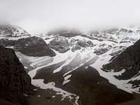
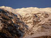
mountain. Permanent glaciers such as Ghashmastan, Bozkosh, Pidini,
Kaladun, Abesepid, Karsomi, Kaykhosro and Pazanpir are the main source
of water in Padena and Boyerahmad region. Dena is source of tens of
streams and rivers including Kor River in the northwest of Fars
Province, Marbor River in the south of Isfahan Province, and Bashar
River in the east of Kohkiluyeh & Boyer Ahmad Province. There are
also lots of springs in the area, especially in the northern aspect of
Dena which has brought about the economic growth in indigenous areas.
Tang-e-shambalaydun in the western aspect, Sichani Spring in the
southern aspect, Chekonam Spring on the path to Bijan Gorge, Salt,
Atabaki and Mojez-gah springs in the northwest of Dena, and also Bard
Spring, etc. are the main tourist attractions in the area. The abundance
of water has made the gardens in Padena – a region in the northern
aspect – a major source of fruits including apple, a universally
well-know product of Zagros. Other provinces in the south and southwest
of country also use these sources of water for agriculture,
horticulture, and livestock farming. Naturally and geologically unique
caves are another spectacular tourist attraction in the region.
Kaykhosro (to the SE of Khafr Village) and Yakh (Kaykhosro Gorge,
elevation: 3850m) are the most famous caves of Dena. Yakh Cave possesses
many beautiful ice columns (sometimes 15m thick) and waterfalls which
make the area a spectacular tourist site. Serving as an important source
of water in Padena, Dangezlu is another cave to the SW of Dangezlu
Village (east of Dena). Padena region, located to the north of Dena
Mountains, has a rural and nomadic structure resided by Farsimadan
sub-tribe of Ghashghai tribe. There are also many villages in the
southern aspect of Dena to Yasooj City and Bashar River, including
Khoongah, Dashterez, Bonzard, Chenar, Badengoon, Pataveh, Abzar,
Sameron, Sarasiab, Kori, Tootnadeh, Dareshahi, Abgarmak, Kookhdan,
Dehbaraftab, Gangei, Madoan, and Mehrian. Sisakht city is the second
city (after Yasooj) in the southern aspect of Dena. It is also the
center of newly established Dena Township. Sisakht is the starting point
to many ascents to Dena peaks. Padena, villages of Abmalakh, Sivar,
Mandegan, Khineh, Khafr, Nourabad, Shaybani, Durahan, Beedeh, Dashtbal,
Durgan, Tolmohammad, Kahangan, Dangezlu, Noghol, and Shahid are located
in the northern aspect of Dena. Dezkord Village in Fars Province, Kakan
County in the east of Kohkiluyeh & Boyer-Ahmad Province are located
in the eastern aspect of Dena.
By : Fars Green Center
By : Fars Green Center
Houzdall 4360m
Routes north wing
Dena
climb the main routes in the north wing, which are longer and the
rivers and springs and Brfgyrtrnd Fravantry with pastures and fields are
Stepan. Mbdahay major climb in the village water shrimp Jbhh northwest,
then Saver, fatigue at the front north and central part of the area
north and Dena village Jbhh Khafr and eastern, and The Village Dngzlv
Dena can be reached peaks. Locust valley water path and Atabak Shlmk
narrow channel can be a total Qdvys climb. The first route path from the
village Saver narrow channel formed Rzk Rzk and neck and then the path
of fatigue and Rvdqr narrow channel formed in spring Atabak Moore
stable, treated, and jointly reach the peak total Qdvys. Azrvstay
fatigue in narrow channel can be used to narrow Qr Lai peas and all
Qlhhay Jbhh rose from the northwest Khtalras be conquered. This route
can also Qlhhay west wing, narrow channel of water Qlat goat Khersan
Aspyd and East and West and the total climb was Farhad. Village Khafr,
major central Jbhh Qlhhay Mbdabray to climb, especially Dena Dena slice
Mastan, ie the highest height is 4435 meters. To achieve slice Mastan,
the village Khafr narrow channel behind castle hill fort east wing to a
height of 2480 reach shelter where another path along which Khafr Khafr
waterfall in the western wing of the castle hill and then deal the
narrow channel and then slice Mastan Mastan stem slice in the western
wing peak, climb it is possible. Khafr that Khafr waterfall beside the
castle hill is located west wing will encounter narrow channel and then
slice slice cervix and Mastan Mastan peak in the western wing, climb it
is possible. Path to towards Khafr Qlhhay West Mastan slice of the
mountain side and edge Ben Ben Shahi Dal Shahi, a pond and from there
north Aspyd total water and total water millet is mounted. The next path
is separated from West Khafr Gvdbrh duct to the narrow neck Kaladvn and
Eastern Pvtk and then reaches the peak Pvtk. Lvkvrh, all neck and neck
mass and flower Paznk and Moore also this route through the valley can
be accessed by following Danny. Next major source, villages and Dngzlv
The Eastern Front, the flagship Dena ascent route to South Qlhhay null,
null north salt, snow grubby, total gate (total harvest) is null and the
narrow channel north to the south, such as in a junction col null
(height 3750) The path that comes from dealing and said the Qlhhay makes
available. Rvstaynql along the river on a path on the Tapv Yalgvrab
peaks can Tapv, slice red, Nvljnvby be conquered northern and null.
Other Drmsyr same Rvstamytvan Rmbs·h the narrow channel and the peak
Rmbs·hrsyd Rmbs·h Jnahghrby wall in the path towards the West and slice
red and null Tapv South East side to the highest peak reaches Pazn old
Dena eastern wing height is 4302 meters. 4000 Ynhamdhtryn
Msyrhaysvdbhqlhhay Balatraz Mtrdnavsrshar of glory and beauty that are a
surprise glen spring and passed Ykhchalhayy that all current year and
alive. Kohgiluyeh and Boyer Ahmad and Dena Mountains in the east and is
located in the NE 29 degrees 56 minutes 29 minutes 31 degrees northern
latitude and 49 degrees 53 minutes 53 minutes 51 degrees east is. The
extent of 16,264 square kilometers and have the latest Administrative
divisions of 8 cities, 12 districts, 38 municipalities and 2,026
villages and towns residents are having. Kohgiluyeh population
statistics in 1375, according BoyerAhmad 544,356 people which is the
rate of 2 / 39 percent of it (213,563 people) in urban areas and 8 / 60
percent (330,793 people) lived in rural areas and ethnic groups are.
Average annual population growth Kohgiluyeh and Boyerahmad ten year
period 1375 to 1365 digits equal 83 / 2 percent shows the growth rate in
urban areas and 7 / 5 percent in rural areas and 96 / 0 respectively.
Kohgiluyeh and Boyerahmad Kvhstanytryn provinces of Iran. C Nyryanvr
capital. B height 3415 m, 3172 m raw northeast the dome, Khanyr downtown
attractions and luminous Maghrvdl are located in the north. Dena
Mountain in the eastern wing Hjal height of 3462 meters of vegetation
and plant diversity is desirable and in the Foothills dense oak forests
there. Dena to southeast towards the northwest of Fars Province, there
are Artfaaty Dena that are considered more typical. Highest Qlhhay this
section, the peak height Firouzm suffering with the height of 3750
meters and 3850 meters north Ardakan (Resort) are. Transition in the
Zagros Mountains to the mountains of southern Fars province rich Rising
reach. Mountains of Fars, classes Eocene, huge masses form. Wrinkling in
the area is low and still lose their primary mode have left. Qlhha and
more Frvrftgyha were parallel to each other. Normal rainfall in the
River very large and there are no broad valleys. Large area with trees
and dense forest Kvhmrh and nutritious and abundant springs of similar
climatic conditions has Bak·hkylvyh BoyerAhmad and Dena and ecosystems
in mountainous part of the ecosystem and forest and pasture is similar
to Dena. This area along the southern branch lead Alyh Zagros mountains
parallel Barshth 1000 to 3000 meters in height and swing the bucket
highest peak is 3,150 meters high. Kvhmrh area between the north and
northeast of Shiraz and Kazeroun there to the northwest Firoozabad
Brmygyrdk·h heights less than three thousand meters and lakes and rivers
Famvr and Arjan plain to the south of Nagorno-hazel is now includes.
by : fars Green Center
by : fars Green Center
Mourgol Peak
More ...
Fountion
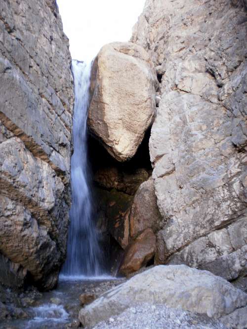
(spring) : 117 Sprins -- Mishi , Tang-e-hara , Houzdall , Geroi , Bon
Rood , Zangoi , Siah , Siah Ab , Ab mohkami , Chekta , Naft Dan , Gol
par , Bard Cheshme , Nari
Waterfall : Takht-e-Soleiman , Dar-i-Anari , Tof-e-Shah , Bon Rood , Chadoni , Pidini , nevel
Glacier : Zendan and any snow-drift in Massif
Valley : Bozkosh Valley, on the ascent to Howzdal-e-markazi, is a well-known valley in Dena. Valleys in the southern aspect of Dena include Putak, Abzar, Sorkh-e-moradi, Barf-anbar, while Pidini, Ghash-mastan, Kaykhosro, Sibi, Pasdena, and Abshar are the valleys in the northern aspect. Slopes in the southern aspect include Shenaki, Tufan, Chalzard, while Bonshahi, Bordsefid, and Gurab are the valleys in the northern aspect of Dena.
Gorges and Passes : Maymand Pass (elevation: 2560m) in the NW aspect and Bijan Pass (elevation: 3200m – the highest mountain pass in the country) in the southern aspect are the two main passes (both mountain roads) of Dena. Other passes in the southern aspect of Dena include Pazani, Western Putak, Eastern Putak, Kal-e-kharman, Barf-e-kermu, Bar-e-baz, Ghash-sorkh, Tapu, Rah, etc. Other passes in the northern aspect include Tat, Atabaki, Rezak, Abespid, Kaykhosro, Ghash-mastan, Tol-e-gerdal, Lienokhod, etc. Gorges in the southern aspect of Dena include Shambalaydun, Shah-ghasem, Chat-e-sholeh, Ghodvaise, Zuledun, Bavi, Bolio, Nari, Kohgol, Namak, Nevel, Tubadi, and Cheshm-e-kabutari. Gorges of Haydari, Atabaki, and Mojez-gah are located in the western aspect of Dena while gorges of Lienokhod, Khersan-e-kuchak, Rudghor, Abespid, Kharidan, Kaladun, Morgol, Ghash-mastan, Kamar-ghebleh, Kaykhosro, Karsomi, Gerdui, Sarbaz, Nevel-e-shomali, and Tapu are located in the northern aspect.
City or Vilage Near: Sisakht Small City , Yasouj City -- Western : Patavebak Vilag , Ab sepa - Eastern : Komr , Kakan , Shahid , KHafr Vilages
cave : Ice Caves , Cave Cher Cher , Cave Dofiri , Cave Nevel , Water Cave Dan Ghezloo
Field : Small gourgi , Big Gourgi , Kerokhoda
Shelter : 3500 GHash-e-mastan , 3500 Pedeny Spring*Tang-e-Bozkosh (Bizhan & Houzdall)
River : Khersan , Marboroshenar , Khafr , Pol Kaloo , Tapoo
Big wall : western morgel 100meters (4420m) - western ghashmastan 400meters (4500) - heram 150meters (440)
Nevel Waterfall
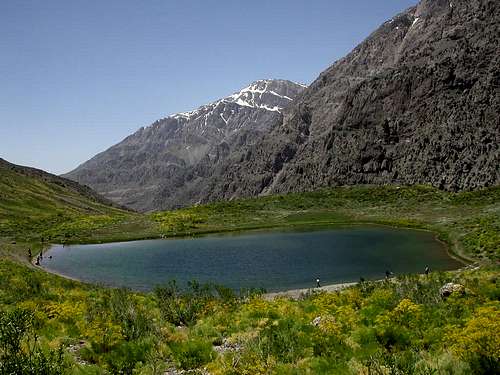
KohGol Lake
Funa & Vegetation
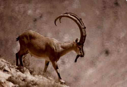
Large
brown bears, partridges, eagles, vultures, bearded vulture, leopards,
wolves, wild cats (Black-eared in particular), martens, ferrets, Persian
squirrels, falcons, larks, rams, ewes, and wild goats make up the local
fauna.
Southern and western slopes of Dena (lower than 2500 m) are covered with forests of oak, wild pistachio, mountain almond, crataegus, woodbine. Shrubs of crataegus, woodbine, astragal, cypress can be found in higher areas (above 2500m). Only small plants and some types of astragal grow above 3500 m up to the peaks. There are no forests in northern slopes; but sparsely located cypress trees, pastures and grasslands can be found. Certain types of plants grow at different elevations, making the whole area rich and diverse in vegetation. Many plants have nutritional and pharmaceutical values. Tulips, orchids, primroses, and tansy are the flowers common in the region.
by : fars green center

in Dena (by F.G.C)
Pazan in Dena (by F.G.C)
Getting there and When to climb
Dena,
climbers paradise is. There are 47 peaks of more than four thousand
meters to place it as climbers approach it has. They both southern and
northern wing to the garden Qlhhay Bymannd to climb. Because the more
southern wing wall section in the category Bvrnapzyr north wing is
suitable for climbing. However, the path to climb the central pool and
slice slab Jbhh Mastan in South Central Dena wing may also. Basin slab
to reach the path of the duct Syskht to stem B. Drhsy Chany whistle to
shelter Pydny that distance is 3 hours following the summit reach. Open
another path that starts from the city Syskht Syskht to the north-west
valley Buzkashi and there seems Pydny shelter. Both the path (each) a
day-trip distance of a source is available to climb the peak range. Dena
in the central wing, also the peak Mvrgl Karami village along the road
axis Yasouj, Maymand can route to Korea Nvmvn first reached the river
and narrow path of the wall following Zvldvn to climb the peak and the
peak total Grdl Administrator and then reached the East and on the main
ridge and the summit will move Mvrgl (second Dena) reached a height of
4425 meters. The other Qlhhayy Jbhh are central, and south and they can
source Syskht Sichani rose and the fire which would stem from both
directions and B. Drhsy Chany are available that can be for one day they
will climb. Dena in the eastern wing (East cervix B.) Qlhhay grubby
snow, salt, total harvest or a gate, can be null route B. cervix are
climbing. Another common way in there tight K·hgl peak except pen, null
path narrow channel, access to Qlhhay total harvest, null southern
sliver Red Tapv, Rmbs·h and makes possible Pazn old. Pazn old to climb
the highest peak of the eastern wing Dnast can narrow path in کبوتری
Jadh Yasouj passed and the District of Kakan Khrsy narrow channel east
wing will climb the peak and reached the peak. Mainstream public course
and climb to the peak of spring water source located in the creek road
to Kakan are Yasouj. The first trench foot mountains and then burned the
cervix are great Gzrym Vicia ervilia then the main base area to climb
the mountain Dena reached. Dena for the south wing to climb Qlhhay Jbhh
western village of origin can be plain and rose to the chal Qlhhay هلی
and total access Qdvys that the narrow channel and narrow Qdvys چات and
should Shlh passed. Considering that this route should be rock by the
elite guides and technical equipment started to climb this mountain.
Similarly, can the westernmost front of the narrow path between the
valleys Shnblydvn climb that wall or part of the following northern
plains horse-mackerel Shvrbh total peak height of 3885 meters saline,
passed and narrow paths of the northern wing Heidari and then water to
shrimp comes to dealing and horse-mackerel salt plains Shvrbh peaks to
the total height and total green چات Pazny Qdvys dates and total.
by : fars green center
by : fars green center
Yasouj City and East dena in up